There is now widespread recognition that failing to identify and locate utility apparatus prior to excavation has an impact not only on project costs and timings but also has major Health and Safety implications. Existing service record drawings should be the starting point for any assessment but the plans are rarely comprehensive and their accuracy can be variable.
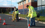
Further work in the form of a non-intrusive survey is required to comply with Section 60 of HSG47 ‘Avoiding danger from underground services’ published by the Health and Safety Executive in 2000. The guidelines detail what sort of devices should be used, including radio frequency locators (RFL) and ground penetrating radar (GPR), and requires that they should be used by suitably trained and experienced operators.
A simple non-intrusive utility tracing survey undertaken prior to the commencement of site work can provide clear and accurate results on the amount and location of buried services and other possible sub-surface hazards. This can:
The Survey Association (TSA) has recently published guidance notes on the different types of utility tracing surveys that are available and categorise them into different levels of survey, all of which Phase SI can undertake in-house.
Click on a survey type below for more information:
This is the most detailed and reliable survey option available.
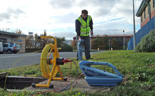
Accessible metallic apparatus is traced by RFL, drainage routes are determined for all pipes, some fibre optic ducts can also be traced. The contents of all chambers are recorded and the site is scanned in passive modes with the RFL.
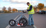
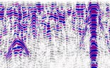
The GPR survey is carried out on a series of recorded grids with data collected in two directions on profiles spaced a set distance apart (usually between 0.5 m and 2.0 m). The data is processed and interpreted off site.
Traced features and the GPR survey grids are tied-in using total stations or RTK GNSS systems. Topographic survey detail can also be tied-in if required.
CAD plans are produced showing the traced apparatus with annotated depths, any relevant topographic features and anomalies identified by the GPR survey.
A Level 6 survey but with limited recorded GPR. The RFL survey covers the entire site but the recorded GPR survey may only cover specific areas.
This type of survey allows for locating metallic and drainage features over an entire site but then provides more detailed information in areas where excavation work may take place.
A combined Level 4 / Level 5 survey can often be a good survey strategy on some sites as the less congested or less critical areas can be targeted by GPR scanning with a recorded GPR survey being carried out over key areas.
Involves the same RFL procedure as a Level 6 survey but the GPR is carried out as a real-time scan or mark-out survey. The GPR data is analysed on site and possible features are marked up.
Tying in and the production of CAD plans is the same as for the Level 6 survey.
Not quite as comprehensive as a Level 6 survey but acceptable to use if apparatus routes are not thought to be overlay complicated or congested. Non-linear features are more difficult to detect and features at depth or in heavily disturbed ground are less likely to be detected compared to a Level 6 survey.
A full RFL survey as detailed in the Level 6 survey but no GPR work is carried out.
Cheaper than a survey that incorporates GPR but is only suitable on sites where non-metallic apparatus is not present or is not of concern.
Determination of drainage connectivity and routes.
Chamber details are recorded including details such as invert levels, pipe diameters, flow direction, type of drainage, pipe composition and any additional information that is specificied.
Manhole record cards and / or schedules are produced.
CCTV surveys of drains 225 mm in diameter or less can undertaken in-house and DVDs showing pipe condition provided.
Usually undertaken to ensure that an intrusive investigation will avoid buried services. Areas are scanned using GPR and RFL and features marked out in real-time
This type of survey usually covers a small area but chambers outside of the target area should still be investigated to check if apparatus from these could cross the site. Features are not usually tied-in (but can be if required) but a photographic record and sketch plan is produced.
A Level 4 survey but usually over a smaller area. Chambers outside of the target area will still be investigated to check if apparatus from these could cross the survey area.
Traced features are tied-in and a cross-section of the apparatus located is usually provided.
This type of survey is not as comprehensive as a full Level 4 survey as all of a site is not covered but it can be used to target key areas within a site.
All potential statutory undertakers will be contacted. Various turnaround options can be provided but drawings are usually supplied by the undertakers in around 2 weeks.
Record drawings can be provided in hardcopy or digital format and a composite CAD plan can be produced if required.
PAS128:2014 (PAS128) is a Publicly Available Specification, produced by the British Standards Institute (BSI), and is titled ‘Specification for underground utility detection, verification and location’. The aim of PAS128 was to provide set specifications / standards for different levels of survey. A client should define the survey type and methodologies needed to meet their objectives and a PAS128 compliant survey is one that meets the specified survey level. A quality level for each type of feature that has been traced is allocated based on the methodology used and how the feature was identified.
The survey methodology specified can utilise either on site mark-out or the collection of GPR data for post-processing and interpretation off site. It is recognised that the latter can provide more detailed and reliable results but often has a greater associated cost.
Phase can undertake all types and levels of non-intrusive utility surveys and if you require a PAS128 compliant survey we are happy to discuss the methodology and type of deliverables that will be most appropriate to your project.
Phase SI will always propose a survey strategy that best suits the project specific requirements using the best available equipment. We will always detail what level of survey our quote is based upon to ensure that our quote can be compared with others on a like for like basis. We can tie in our survey results using total stations or RTK GNSS systems to produce accurate CAD plans or utilities can just be marked out on site.