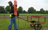
Geophysical surveys involve measuring the physical properties of the ground (or structure) and determining if there are any variations or ‘anomalies’ in the background readings. The occurrence of anomalies can indicate the presence of a feature(s) or changes in a material’s composition. Geophysics is a broad discipline with a wide range of techniques that can be used in a variety of sectors. The focus of our work is usually in the near-surface engineering, environmental and archaeological applications of geophysics. Near-surface, for these applications, generally applies to the upper 5 m of the ground. Greater depth penetration can be obtained but there is a subsequent loss of resolution so that only large features, such as geological variations or mine workings, can be located at depth.
There are a wide variety of geophysical techniques available, each one measuring different physical properties and each being more or less sensitive to different types of feature. The suitability of any given technique will depend on the site specific conditions and the type and composition of likely target features. Often the best geophysical survey results are obtained by utilising several geophysical techniques. It should be recognised that in certain conditions some features may not be identifiable by a geophysical survey and so guidance should be sought as to the suitability of a technique prior to the survey being commissioned.
Many sites may have multiple hazards or requirements; for example a site may have possible archaeological features, buried fuel tanks associated with its recent use and utility apparatus within and adjacent to it. Rather than treating each of these as separate issues a geophysical survey utilising a range of techniques can be carried out which could potentially identify where each of the possible hazards or features are. If the project aims and requirements are made clear prior to commissioning a survey then a more cost-effective strategy can be adopted.
One of the main advantages to using geophysics is that the entire site can be sampled fairly rapidly for a relatively low cost. The data acquired can then allow the optimal intrusive investigation to be determined which will result in more detailed, comprehensive information being obtained about a site. This will usually result in overall project cost savings.
Another major benefit to carrying out a geophysical survey is that the ground or structure is not disturbed so there is no exposure to buried hazards or chance of creating contaminant pathways. Features can be identified without the risk of damaging them, which in the case of buried utility apparatus is critical.
Phase Site Investigations Ltd will tailor the survey to meet the individual project requirements and on larger sites can undertake trial surveys to assess which techniques will provide the required results. It is a key aspect of our services that we produce concise, clear interpretations and reports. We are aware of the needs of the engineer or developer and present our results in scaled CAD plans with an accompnaying report that can be easily understood and used by non-geophysical specialists.