What We Do
land and building surveys
overview
Phase Site Investigations Ltd specialise in topographic, land and measured building surveys where we utilise the latest technologies to measure the built and natural environment. The equipment that we use includes:
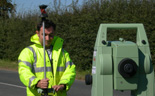
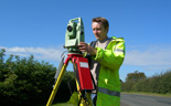
- Reflectorless ‘one-man’ total stations. These high-precision instruments are fully robotic and allow a survey to be carried out by a single operator. Features that are visible but cannot be directly accessed can still be surveyed remotely using the reflectorless mode where a laser is bounced directly off the object.
- 3D laser scanning. These instruments take reflectorless surveying to the next level as they can take thousands of scans per seconds. The instruments are fully automated and can be set to scan across a particular feature or cover an entire site.
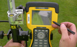
- VRS RTK GPS systems. These are high precision (potentially sub-centimeter) instruments that obtain a geographical fix using a combination of satellites and 3G phone signals.
types of survey
- Topographic
- Measured building surveys including elevations, floor plans and sections
- Historic building assessments
- Rectified photographic recording
- Setting out
- Tying in of boreholes
We undertake all of the above surveys in-house and are one of the only survey companies with a specialist historic buildings surveyor. This means that our historic building recording and assessments are carried out to English Heritage and the Institute of Field Archaeologists guidelines and standards. Check out our heritage section for more details.
We can undertake any of the above surveys as a stand-alone service or as part of a wider service package. As we are able to offer multiple survey options, as well as a range of non-intrusive surveys, including utility tracing and geophysical surveys we can provide significant cost savings compared to carrying out each survey on its own.